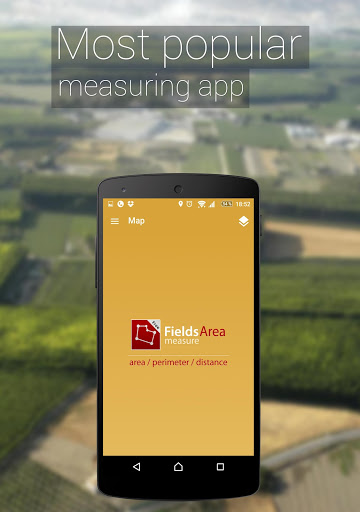
توضیحات جی پی اس محاسبه مساحت زمین
برنامه مفید برای محاسبه محیط یک منطقه، تعیین مسافت و مدیریت محیط و کاملا آسان برای استفاده.
این ابزار برای میلیون ها نفر در سنجش زمین های خود، علامت گذاری به نقاط مورد نیاز خود و به اشتراک گذاری نقشه های اندازه گیری شده خود با همکاران کمک می کند.
وقت خود را در جستجوی بهترین برنامه رایگان برای اندازه گیری مساحت، مسافت و محیط تلف نکنید - برنامه ما را انتخاب کنید و فرایند اندازه گیری را ساده کنید!
ویژگی های منحصر به فرد نرم افزار
GPS Fields Area Measure -
جی پی اس محاسبه مساحت زمین:
- علامت گذاری سریع منطقه / فاصله
- حالت نشانگر هوشمند برای قرار دادن پین بسیار دقیق
- اندازه گیری ها را نامگذاری، ذخیره، گروه بندی و ویرایش کنید
- ردیابی GPS / اندازه گیری خودکار برای پیاده روی / رانندگی در اطراف مرزهای خاص
این همچنین شامل یک ویژگی برای ارسال یک پیوند خودکار ایجاد شده به دوستان یا شرکای منطقه پین شده / منتخب، جهت یا مسیر شماست - منطقه ای را که می خواهید به اشتراک بگذارید نشان می دهد.
یک ویژگی برای افزودن نقطه مورد علاقه یا POI در مزرعه کمک می کند تا از سنگ ها، علامت نرده ها و مرزهای گاوها، چرای مناطق گاوهای لبنی، گاوها، گوشت گاو و سایر دام ها جلوگیری کنید.
اندازه گیری زمینه های GPS همچنین به عنوان ابزاری برای اندازه گیری نقشه برای فعالیت در فضای باز، برنامه های کاربردی یاب و دامنه ورزشی از جمله دوچرخه سواری یا ماراتن مفید است. در هنگام گشت و گذار در منطقه گلف یا به عنوان یک متر فاصله گلف، مناسب برای نظرسنجی از زمین، عملی برای اندازه گیری سطح مرتع مزرعه، مفید در کار یا برنامه ریزی در باغ و مزرعه، بسیار مناسب برای نگه داشتن سوابق منطقه مفید است. برای ساخت و سازها و نرده های کشاورزی بسیار مناسب است. این برنامه حتی برای نصب پانل های خورشیدی، تخمین مساحت سقف یا برنامه ریزی سفر عملی است.
برنامه اندازه گیری ما دارای بالاترین دقت در بازار است، به همین دلیل اصلی ترین دلیل اندازه گیری ما در بین اماکن ساختمانی، پیمانکاران ساختمان و مزرعه و کشاورزان هستیم.
در میان کاربران ما افرادی هستند که بام، ساختمان و راه را می سازند، صاحبان مزرعه که سم پاشی می کنند، کود می کنند، بذر می کنند، مزارع را برداشت می کنند یا در حال زراعت هستند. برای دوچرخه سواری، مسافرت یا برنامه ریزی سفر مفید است. برای رشد باغ ها و گاو، چمنزار یا چمن - ما انتخاب شماره یک هستیم.
از جمله افرادی که در حال پرورش گوشت گاو، گوشت خوک یا مرغ هستند - این برنامه برای اندازه گیری و برنامه ریزی حصار مفید است. خلبانان همچنین می توانند هنگام پرواز در مزارع از این برنامه استفاده کنند. مدیران مزرعه و پیمانکارانی که در حال بهره برداری از کار کشاورزی برای کشاورزان هستند می توانند از این برنامه برای شمارش میزان مزارع کاشته شده و به اشتراک گذاری آنها با مالک استفاده کنند. زمینه ها در Google Maps نمایش داده می شوند.
این بهترین راه حل برای صاحبان مزرعه هایی است که گندم، ذرت، کلزا، ذرت، چغندرقند رشد می کنند و نیاز به اندازه گیری سطح زیر کشت سالانه دارند.
در کل، برای موارد زیر مفید است:
- کشاورزان، برای مدیریت مزرعه
- زراعت شناس
- برنامه ریزان شهر
- نقشه بردار ساخت و ساز
- هنرمندان منظره
- نظرسنجی مبتنی بر زمین
- مدیریت ثبت زمین
- بررسی های ساختمانی
- نقشه برداری بهداشت، آموزش و امکانات
- اندازه گیری مسیر ورزشی
- سایت های ساخت و ساز و محوطه سایت های ساختمانی
- نقشه برداری دارایی
- طراحی منظره
تغییرات نسخه 4.5.1:
اضافه شده قابل تنظیم کلیک طولانی بر روی نقشه.
عکس ها را روی نقشه اضافه کرد.
تنظیمات برای روشن/خاموش کردن ویژگی های مختلف نقشه اضافه شده است.
هنگام انتخاب اشتراک، قیمتهای گمراهکننده را برطرف کرد

 مسیریاب آفلاین - بدون اینترنت
GPS, Offline Maps, Navigation & Directions
 محاسبه مساحت زمین با جی پی اس
Gps Area Calculator for Land Measurement
 جعبه ابزار کامل
Boxi
 سرعت سنج دیجی هود
DigiHUD Speedometer
 گوگل ارث
Google Earth
 سرعت سنج جی پی اس
GPS Speedometer, Distance Meter
 محاسبه گر ابجد
Abjad
 محاسبه گر
Calculator
 گوگل
Google
 مترجم گوگل
Google Translate
 گوگل پلی سرویس
Google Play services
 شیر ایت - اتصال و انتقال
SHAREit - Connect & Transfer
 تست سرعت اینترنت
Speedtest.net
 اندروید سیستم وب ویو
Android System WebView
 متن به گفتار گوگل
Google Text-to-Speech
 کرنومتر - زمان سنج
LapStar Stopwatch
 تست سرعت اینترنت
Internet Speed Test
 لمس لبنان
touch Lebanon
